
News
The macabre Yorkshire ‘death walk’ where you’re made a witch at the end
Some people even dress up as undertakers and carry (empty) coffins with them as they go along the Lyke Wake Walk.
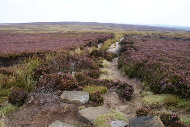
Walks on the moor tops can often feel somewhat bleak and ghoulish, but this 40-mile epic hike brings a whole new level of morbidity to traversing this particular part of the country.
Inspired by an ancient Yorkshire folk song called Lyke-Wake Dirge that dates back hundreds of years and is sung in a now-extinct Yorkshire dialect, the Lyke Wake Walk is a macabre pilgrimage of sorts.
First, let's break down the name. Lyke is old Yorkshire dialect for a corpse, whilst 'wake' is the act of watching over it, making the walk a sort of death march that's said to be the Yorkshire equivalent of climbing Mount Everest or Ben Nevis.
A 40-mile challenge that requires a complete crossing of the North Yorkshire moors, it's not for the faint of heart, which only makes it more incredible that some people actually dress up as undertakers and carry (empty) coffins with them as they go.
Along the way you'll navigate sharp ravines, make countless stone crosses, tackle near-vertical ascents of 5,000 feet and risk a bog that, according to one guidebook, you'll "either bounce across" or find yourself "up to your waist", depending on the time of year and recent rainfall.

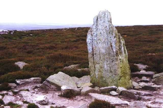
You'll pass howes (ancient burial mounds) and tumuli (mounds of earth and stones raised over a grave or graves) on your way, as well as medieval crosses and what one intrepid hiker in the Guardian called "the sinister pyramid of the RAF Fylingdales early-warning system."
Up here, monuments from different periods give the moor a sense of timelessness and, yes, conjure up a range of emotions.
The challenge is just as much a psychological one as it is physical. It's definitely not for the inexperienced. So why do so many people tackle this walk and how has it achieved such cult-like status?
In part, it's due to the fact that if you manage the trek in 24 hours you can declare yourself a witch. And who doesn't want that?
The origins of the Lyke Wake Walk
The walk originates from an article written in the Dalesman magazine in 1955 by Bill Cowley. In it, walkers were challenged to complete the route in 24 hours.
Cowley, a North Yorkshire farmer, apparently insisted that a “solemn silence should always prevail” when undertaking the walk - but today, many choose to chat or sing the folk song from which it takes its name as a tonic to the gruelling journey.
Back when the walk was first conceived by Cowley, there was no path and early intrepid explorers were literally pushing through heather back in October 1955, when the first successful crossing took place.
Today, it's typically accepted to start at Scarth Wood Moor and take a signposted path across to Ravenscar, which follows a so-called 'coffin' route and includes sweeping views of pastoral plains that stretch for miles.

As we've already mentioned, there are tales of some people going the whole hog and dressing up with coffins, inspired by (unsubstantiated, yet darkly romantic) stories of coffins being carried across the moors in days of old.
But in truth, the real connection with death and funeral processions is that rather than following someone else's, by the end you feel like you've completed your own. Broken toes, wrists and other injuries are common.
We told you it was rather morbid.
The walk has achieved such cult-like status over the years that there's even a special club for those dedicated to wandering this particular part of the country. The New Lyke Wake Club.
Membership is free, but you must first complete the 40-mile walk in 24 hours and submit a report. After that, you'll be initiated and can declare yourself either a witch or a dirger.
One club member, Gerry Orchard, has apparently completed it over 200 times.

The route
The Lyke Walk is a complete crossing of the North Yorkshire Moors along their main east-west watershed between the Stone at grid reference 470994 and the Trig point at 971012, a distance of approximately 40 miles.
The route has changed a little since its inception in the fifties, as the arrival of Fylingdales early warning base in 1962 forced it to shift. Officially, there's not a 'set' path but there is now a generally-accepted route that most people undertake.
Starting at Scarth Wood Moor trig point or the western Lyke Wake Stone in Sheepwash car park, if you follow the advice of the New Lyke Walk Club guidebook you'll begin by taking the near-vertical summit track of Cleveland Way.
Well signposted (and occasionally decorated with small wooden coffins, painted in black by some guerilla hiker), this will take you from Live Moore over Carlton Moor, Cringle Moor, Cold Moor and Hasty Bank, before venturing through the wonderfully-named Smuggler's Trod to Bloworth Crossing.
Here the Cleveland Way strikes north, and the Lyke Wake Walk follows the dismantled Ironstone Railway line for about 7km/4½ miles until it reaches the Lion Inn at Blakey.

The Lion Inn makes a great stopping-off point, with a kitchen serving until 10pm and rooms upstairs that you can rent for the night.
From Blakey follow the road round until just after the Fryup turning, from there to Wheeldale the route is undefined, and broadly follows the boundary stones (and the District council boundary) to the Blue Man-i-th'-Moss standing stone then along the watershed to the Wheeldale Road. Careful navigation is required.
The 6km/3½ miles from the Wheeldale Road to the A169 road at Eller Beck is popular with weekend walkers and consequently is much better defined. In short order, you cross the Roman Road, the stepping stones over Wheeldale Beck, and pass the former youth hostel at Wheeldale Lodge. Here, you'll see the early warning station in all its imposing glory.
The route past the early warning station crosses MoD land. You can get through, but take care to follow the path along the bank of the stream.

You then continue through Fen Bogs and Eller Beck on to Lilla Cross, a journey of about 3½km/2 miles, before continuing 6km/4 miles to the A171 road near Jugger Howe ravine. Cross Stony Marl Moor, managed by the Hawk and Owl Trust, before finishing at the eastern Lyke Wake Stone at Beacon Howes or Ravenscar.
To say that from the A171 road it is "only" 2½km/1½ miles to the end at the trig point by the radio mast underplays the reserves of energy that need to be drawn on to climb that last hill, but it can be done and thousands have done it.
The original tradition was to continue the extra mile to the bar of the Raven Hall Hotel, which in practice brings the total distance up to approximately 40 miles.
To find out more about Lyke Wake Walk, read others' accounts, purchase the guidebook and discover the route in more detail, click here.
Feature image - Wikimedia Commons